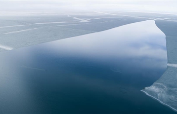
BEIJING, April 14 (Xinhua) -- A team led by Chinese researchers has revealed the fine-scale surface features of the Antarctic sea ice by using drones to acquire high-resolution images and data, according to a study published in the international journal Remote Sensing.
In 2016 and 2017, researchers from Beijing Normal University participated in China's 33rd Antarctic expedition. Using the unmanned aerial vehicle (UAV) "Polar Hawk-III," they obtained remote sensing data of sea ice in the east Antarctic, to offer support for China's research vessel and icebreaker Xuelong (Snow Dragon).
This is the first time that Chinese researchers used drone technology in surveying and mapping large areas of Antarctic sea ice. Previously, researchers had to carry a GPS and use a helicopter to explore, according to Li Teng, a researcher in the study.
The UAV observations have provided detailed characterizations of sea ice surface topography, especially the fine-scale features of ice ridges, which is still a challenge for satellite systems.
Researchers believe the UAV observations will have broad application prospects in sea ice research and polar exploration, such as observing sea ice melting processes, helping guide icebreakers and reducing transportation risks.
Scientists from Newcastle University and Northumbria University in Britain and Environment Canada also participated in the study.
The Polar Hawk-III is a fixed-wing drone with an integrated remote sensing system. It was jointly developed by Feima Robotics Laboratory and Beijing Normal University. It has a wingspan of 1.6 meters, weighs about 3.3 kg and costs 6,500 U.S. dollars.